Salt Lake City, UT
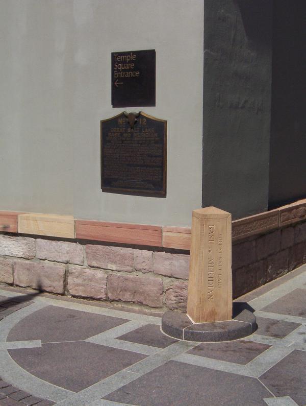
Meridain Marker
GPS Coord: N 40° 46.150 W 111° 53.483
This marker defines the boundaries of Temple Square and serves as the originating point for the city's street numbering system, established by Orson Pratt in August 1847. The stone marker was later set by U.S. surveyor general David Burr. The city plan of wide streets and consistently numbered, uniform blocks was visionary.
Behind the meridian marker, notice the sandstone base to the 13 - foot high adobe wall sorrounding the temple, preserved since 1857. Also on this same corner, notice the bust of Utah's famous pioneer photographer Charles Savage, remebered here as founder of Old Folks' Day.

Subscribe to:
Post Comments (Atom)
4 comments:
The official B&M is inside Temple Square, just behind the wall.
-Bob
I'm looking for information on the earth's meridian, I was told that it went right through Salt Lake City. Do you know anything about it?
Your site is interesting! We are related to the Savage mentioned, and I have several temples on my blog, but not any foreign temples. My son is the head-engineer at the Rexburg Temple and was an engineer in the Bountiful temple. My website is:http://peggysazlife.blogspot.com
Peggy Knowles
I am so glad to have read this.
Historical Marker
I was a title searcher in Utah, so I know that the marker is one of two markers from which all land in Utah is measured. If you get our your Title insurance policy, you can read the property description, which usually says something like, "Starting at a point at the NW corner
of the SW quarter of the 15th section from the Salt lake base and meridian, and the details of the description go on, but all but the most north eastern part of Utah are measured from the Salt Lake Base and Meridian. If you find stone markers of this type on your land DO NOT MOVE THEM. They are the method of measuring your land to mark the boundaries between you and your neighbors.
Post a Comment