Pages

Sunday, March 14, 2010

Martin Harris Gravesite

Location: Clarkston, Utah
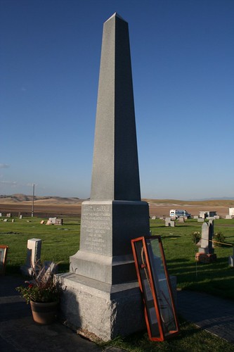
Address: Clarkston Cemetary
GPS Coords: 41°55'52.08"N ;112° 2'24.74"W


Martin Harris was one of the Three Witnesses of the Book of Mormon, he rejoined with the LDS saints in Utah from Kirkland, Ohio in 1870. Martin was at the age of 87. He settled in Cache Valley, Utah, where he died just 4 and a half years later on July 10, 1875. Although Martin left the LDS Church for a time, he returned to full fellowship and was re-baptized before passing away in Clarkston, Utah.

Upon his death, Martin was placed in his casket with a copy of the Book of Mormon in his right hand and a copy of the Doctrine & Covenants in the left to represent his role in financing the publication of the first editions of these two books of Latter-day Saint scripture.

His grave was originally marked with a wooden headboard and a raised mound of earth. On July 10, 1925, the 50th anniversary of Martin Harris' death, LDS Church President Heber J. Grant dedicated a large granite monument on the gravesite with an inscription telling of Harris' role as a special witness and his testimony of the Book of Mormon. Also, a copper box containing a Book of Mormon, a Doctrine & Covenants, and testimonies of many of the people who had known Martin and heard his testimony was placed at the base of the monument.

In the 1980s, an amphitheater was built near Martin's grave. It was dedicated on August 3, 1983 by President Ezra Taft Benson, and each year in August a historical musical play titled 'Martin Harris, the Man Who Knew' is performed before thousands of people. In so doing, the people of Clarkston carry on Martin Harris' charge to tell the world his story and testimony of the restored gospel.


If you happen to have the GPS location for this gravesite please send it my way.

Friday, June 02, 2006

Still working!!

I'm still working on my map of all the temples. I've completed the United States and Canada, now I'm stuggling to find the temples in other countries, where there is no way to search for addresses. So I'm trying to find them through satellite imagery. If by chance you have the Latitude and Longitude of some forieng temples, make sure to send them my way.

I just started a different project, but the same concept. It's actually the original goal of this blog. I'm plotting all the church history sites on another map. What a great source of information that would be.

Saturday, November 12, 2005

LDS Temples: "Temples will dot the earth"

I'm excited to announce my newest endeavor to document the history of the church. As you all know I want to locate all the GPS coordinates of Church history sites throughout the world. Using google maps I have been able to start documenting the location, address, and gps coordinates of the temples of the world. My project is called LDS Temples: "Temples will dot the earth". I have placed the location of most of the temples throughout the United States and I hope to complete all the temples in the near future. Feel free to comment and add pictures of your favorite temple. I will also be adding Church history locations on the map. All these maps are interactive so you can zoom it to the particular street that the temple is on. The map also has the option of satellite views which makes it pretty cool.


For a even better birds eye view of the temples download a free version of Google Earth. Click here for that. Play around with it for a while to get acquainted with the tools and then go to my map click share at the bottom and right click on Google Earth. Save the file. Then pull up Google Earth and go to open and bring up the saved file. Pretty cool stuff.

Friday, November 04, 2005

1st City in Idaho


1st City in Idaho
Franklin, Idaho
GPS Coord:
Address:

Franklin, Idaho was the 1st city built in Idaho. The town of Franklin was founded in the spring of 1860 by Mormon pioneers moving north through the Cache Valley of Utah. These early pioneers believed they were still in Utah, and not until 1872 did an official boundary survey fix the Idaho-Utah border a mile south of where Franklin was established. First settlers laid out wide streets and held a drawing to distribute town and farm lots. Town lots were large enough to accommodate a garden, barn, and outbuildings. Space was reserved for a central square -- which today is the Franklin City Park.Make sure to visit: Relic Hall, ZCMI Co-op, the Hatch House, the old City Hall, and the Franklin City Park. You might also find the distinct Pioneer Monument, a stone spire topped by an eagle that was erected in 1910 to honor the settlers of this territory. Also one of the last Yellowstone Markers is found here as well. These boulders featured an arrow welded to the top to point the way to Yellowstone National Park. As you leave the town, notice the hill to the west and its tribute to the year Franklin was settled.

Wednesday, October 19, 2005

Oneida Stake Academy

Preston, Idaho
Oneida Stake Academy
GPS Coords:
Address: Recently moved to Benson Park


The Oneida Stake Academy was built in 1890 -1894 by German immigrant John Nuffer at a cost of between $46,000. The church architect Don Carlos Young drew up the plans for the building. The cornerstone was laid on July 2, 1891 and President George C. Parkinson offered the dedicatory prayer. The building was finally completed in 1894; it was dedicated by Moses Thatcher who was in the council of the twelve apostles. The academy was one of the premiere primary and secondary schools in the northern Utah-southern Idaho area for several decades. It was the center of education for the region between Franklin and Pocatello at one time.
The Academy helped educate several LDS Church leaders, including Harold B. Lee and Ezra Taft Benson were educated there. Another notable name to emerge from the academy was Samuel P. Cowley. Now known as a famous FBI agent, he was killed while trying to arrest notorious mobster "Baby Face" Nelson.

The academy is believed to be the oldest of 35 such academies built between 1888 and 1909 at scattered locations around Utah, Idaho, Wyoming, Arizona, Mexico and Canada. The academies were forerunners to the LDS Church Educational System and seminary program. It was first dedicated 109 years ago by LDS apostle Moses Thatcher. Other academies built at the time were the Bannock Stake Academy, Sanpete, St. George and Brigham Young. Those schools went on to become Brigham Young-Idaho, Snow College, Dixie State and BYU respectively after the church abandoned the academy system in 1922.

The academy has once again made history in 2003 when it was moved, in one piece, to its new home in Benson Park in the city center of Preston. As far as we know, the Academy is the largest, highest, and heaviest building to be moved intact in U.S. history.

Friday, October 07, 2005

Chesterfield Pioneer Ghost town


Chesterfield, Idaho
Pioneer town
GPS Coord: N 42°51.576 W 111°54.36

Chesterfield is an early pioneer settlement established in 1880 that is now unoccupied. It was originally said to be named for founder Chester Call; others said it was named for his birthplace Chesterfield, England. The Oregon Trail passed through the town, and the settlers helped travelers who at this point were tired, or ill. The town grew to some 400 people, but eventually the changing world brought about its abandonment. The Oregon Trail fell into disuse, the railroad and main roads passed far to the south by Idaho Falls.
A visit to Chesterfield is a unique trip back in time and a chance to experience the rural agricultural life of a community whose deep faith helped them endure the hardships of life on the frontier. There are 27 structures overlooking the beautiful Portneuf Valley near Bancroft. Chesterfield is being restored by descendents of the early settlers and volunteers. The meeting house now is a museum and tours are available.

Address:
From Interstate 15, head east on US Highway 30 towards Soda Springs, Idaho. About five miles past Lava Hot Springs, Idaho take the local road to Bancroft, Idaho. Continue for another ten miles north to a town time has forgot, Chesterfield.

Monday, September 19, 2005

Salt Lake City Meridian Marker

Salt Lake City, UT
Meridain Marker
GPS Coord: N 40° 46.150 W 111° 53.483

This marker defines the boundaries of Temple Square and serves as the originating point for the city's street numbering system, established by Orson Pratt in August 1847. The stone marker was later set by U.S. surveyor general David Burr. The city plan of wide streets and consistently numbered, uniform blocks was visionary.
Behind the meridian marker, notice the sandstone base to the 13 - foot high adobe wall sorrounding the temple, preserved since 1857. Also on this same corner, notice the bust of Utah's famous pioneer photographer Charles Savage, remebered here as founder of Old Folks' Day.