I'm excited to announce my newest endeavor to document the history of the church. As you all know I want to locate all the GPS coordinates of Church history sites throughout the world. Using google maps I have been able to start documenting the location, address, and gps coordinates of the temples of the world. My project is called LDS Temples: "Temples will dot the earth". I have placed the location of most of the temples throughout the United States and I hope to complete all the temples in the near future. Feel free to comment and add pictures of your favorite temple. I will also be adding Church history locations on the map. All these maps are interactive so you can zoom it to the particular street that the temple is on. The map also has the option of satellite views which makes it pretty cool.
For a even better birds eye view of the temples download a free version of Google Earth. Click here for that. Play around with it for a while to get acquainted with the tools and then go to my map click share at the bottom and right click on Google Earth. Save the file. Then pull up Google Earth and go to open and bring up the saved file. Pretty cool stuff.
Saturday, November 12, 2005
Friday, November 04, 2005
1st City in Idaho
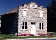
1st City in Idaho
Franklin, Idaho
GPS Coord:
Address:
Franklin, Idaho was the 1st city built in Idaho. The town of Franklin was founded in the spring of 1860 by Mormon pioneers moving north through the Cache Valley of Utah. These early pioneers believed they were still in Utah, and not until 1872 did an official boundary survey fix the Idaho-Utah border a mile south of where Franklin was established. First settlers laid out wide streets and held a drawing to distribute town and farm lots. Town lots were large enough to accommodate a garden, barn, and outbuildings. Space was reserved for a central square -- which today is the Franklin City Park.Make sure to visit: Relic Hall, ZCMI Co-op, the Hatch House, the old City Hall, and the Franklin City Park. You might also find the distinct Pioneer Monument, a stone spire topped by an eagle that was erected in 1910 to honor the settlers of this territory. Also one of the last Yellowstone Markers is found here as well. These boulders featured an arrow welded to the top to point the way to Yellowstone National Park. As you leave the town, notice the hill to the west and its tribute to the year Franklin was settled.
Wednesday, October 19, 2005
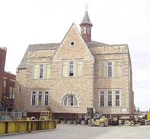
Oneida Stake Academy
Preston, Idaho
Oneida Stake Academy
GPS Coords:
Address: Recently moved to Benson Park
The Oneida Stake Academy was built in 1890 -1894 by German immigrant John Nuffer at a cost of between $46,000. The church architect Don Carlos Young drew up the plans for the building. The cornerstone was laid on July 2, 1891 and President George C. Parkinson offered the dedicatory prayer. The building was finally completed in 1894; it was dedicated by Moses Thatcher who was in the council of the twelve apostles. The academy was one of the premiere primary and secondary schools in the northern Utah-southern Idaho area for several decades. It was the center of education for the region between Franklin and Pocatello at one time.
The Academy helped educate several LDS Church leaders, including Harold B. Lee and Ezra Taft Benson were educated there. Another notable name to emerge from the academy was Samuel P. Cowley. Now known as a famous FBI agent, he was killed while trying to arrest notorious mobster "Baby Face" Nelson.
The academy is believed to be the oldest of 35 such academies built between 1888 and 1909 at scattered locations around Utah, Idaho, Wyoming, Arizona, Mexico and Canada. The academies were forerunners to the LDS Church Educational System and seminary program. It was first dedicated 109 years ago by LDS apostle Moses Thatcher. Other academies built at the time were the Bannock Stake Academy, Sanpete, St. George and Brigham Young. Those schools went on to become Brigham Young-Idaho, Snow College, Dixie State and BYU respectively after the church abandoned the academy system in 1922.
The academy has once again made history in 2003 when it was moved, in one piece, to its new home in Benson Park in the city center of Preston. As far as we know, the Academy is the largest, highest, and heaviest building to be moved intact in U.S. history.
Friday, October 07, 2005
Chesterfield Pioneer Ghost town
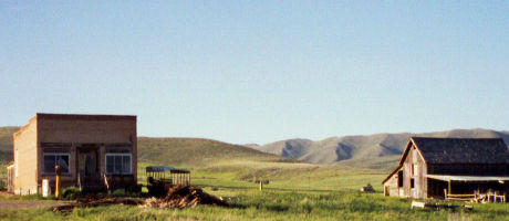
Chesterfield, Idaho
Pioneer town
GPS Coord: N 42°51.576 W 111°54.36
Chesterfield is an early pioneer settlement established in 1880 that is now unoccupied. It was originally said to be named for founder Chester Call; others said it was named for his birthplace Chesterfield, England. The Oregon Trail passed through the town, and the settlers helped travelers who at this point were tired, or ill. The town grew to some 400 people, but eventually the changing world brought about its abandonment. The Oregon Trail fell into disuse, the railroad and main roads passed far to the south by Idaho Falls.
A visit to Chesterfield is a unique trip back in time and a chance to experience the rural agricultural life of a community whose deep faith helped them endure the hardships of life on the frontier. There are 27 structures overlooking the beautiful Portneuf Valley near Bancroft. Chesterfield is being restored by descendents of the early settlers and volunteers. The meeting house now is a museum and tours are available.
Address:
From Interstate 15, head east on US Highway 30 towards Soda Springs, Idaho. About five miles past Lava Hot Springs, Idaho take the local road to Bancroft, Idaho. Continue for another ten miles north to a town time has forgot, Chesterfield.
Monday, September 19, 2005
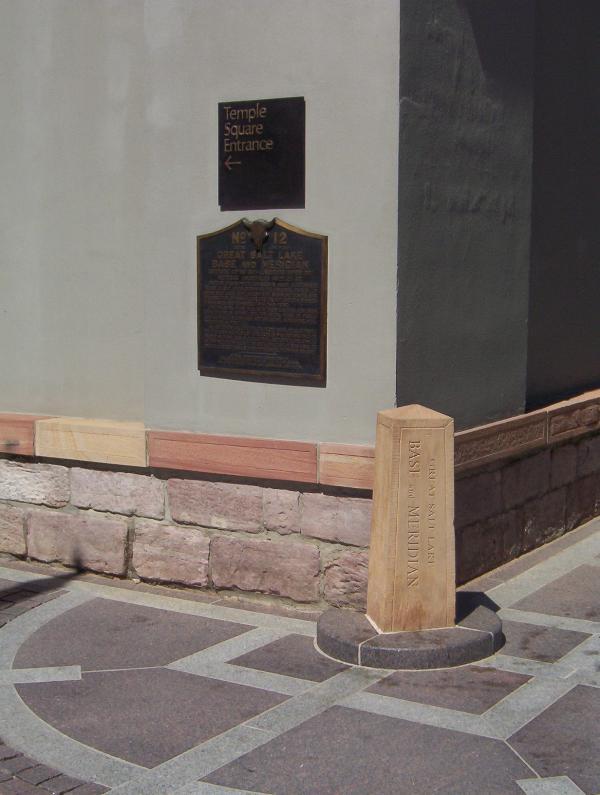
Salt Lake City Meridian Marker
Salt Lake City, UT
Meridain Marker
GPS Coord: N 40° 46.150 W 111° 53.483
This marker defines the boundaries of Temple Square and serves as the originating point for the city's street numbering system, established by Orson Pratt in August 1847. The stone marker was later set by U.S. surveyor general David Burr. The city plan of wide streets and consistently numbered, uniform blocks was visionary.
Behind the meridian marker, notice the sandstone base to the 13 - foot high adobe wall sorrounding the temple, preserved since 1857. Also on this same corner, notice the bust of Utah's famous pioneer photographer Charles Savage, remebered here as founder of Old Folks' Day.

Saturday, September 17, 2005
Ensign Peak
 Salt Lake City, UT
Ensign Peak
GPS Coord: ?
Ensign Peak is the summit of a hill just north of downtown Salt Lake City (1.4 miles north of the Salt Lake temple); in fact, Salt Lake City was built exactly south of Ensign Peak. The peak rises 1,080 feet above the valley floor and stands out as a prominent geological formation evident from all directions. The summit is rounded, devoid of vegetation, and capped with a hard conglomerate stone formation. It is part of the foothills of the Wasatch Range.
On 26 July 1847 Brigham Young and several others climbed to the top which he named "Ensign Peak," as he reported the event in his journal. They used the view from the summit to visually explore the entire valley.
The significance of the name, according to the pioneers, comes from the biblical prophecy: "He will lift up an ensign unto the nations. . . . He lifteth up an ensign on the mountains." (Isa 5:26; 18:3). The pioneers did not erect the U.S. flag on the Peak on 26 July as widely reported, but they did plan to fly the "Standard of the Nations," an invitation for all nations to immigrate to Utah.
The locating of the east side of the temple just south of this Peak comes from the statement of George A. Smith who explained that while still in Nauvoo, Illinois, Brigham Young "had a vision of Joseph Smith who showed him the mountain we now call Ensign Peak. . . . and there was an ensign [flag] fell upon that peak, and Joseph said 'build under the point where the colors fall and you will prosper and have peace'." Hence, Temple Square and Salt Lake City were laid out due south of the peak.
From this peak at least one departing Mormon missionary received the temple ceremony. Addison Pratt, about to depart to Hawaii in 1849, was taken to the summit of Ensign Peak and there received the endowment from Brigham Young and several leading elders. Brigham Young said he specially consecrated the Peak for this purpose.
Many organizations in the State have adopted "Ensign" as part of their name, such as: Ensign Stake, Ensign Ward, Ensign Elementary School, Ensign Magazine, among numerous other.
See: B.H. Roberts, Comprehensive History of the Church, (1930); and Lynn M. Hilton, Story of the Salt Lake Stake (1972).
Saturday, July 30, 2005
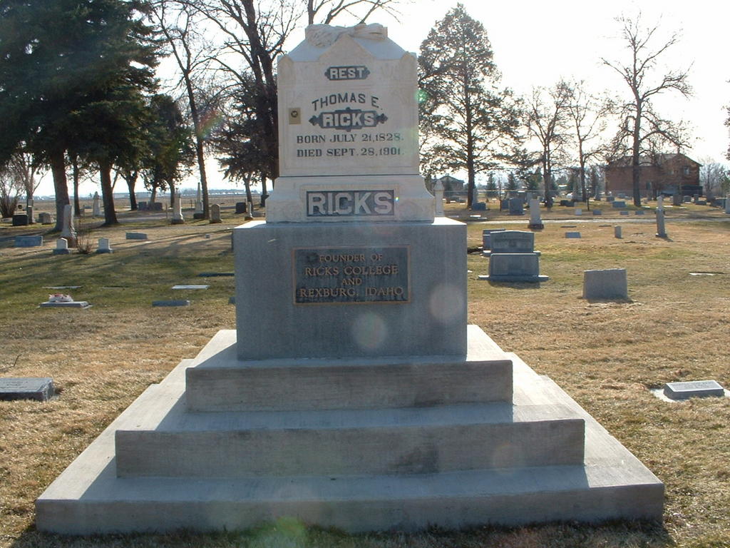
Thomas E. Ricks Grave (Founder of Ricks College)

Rexburg, Idaho- Rexburg cemetery
- GPS Coord: ?
A group of young Mormon men from Cache Valley, Utah, was organized to form a settlement in the area. Among these men was Thomas E. Ricks, founder of both Rexburg, and Ricks College (now BYU-Idaho). In February 1883, they cut logs for building a community in the spring. In March the men met at the present town site of Rexburg and constructed the first log house. The settlers first decided to call their town Ricksburg after their settlement leader, Thomas E. Ricks. However, since the German ancestral name of Ricks is Rex the town's name was changed to Rexburg.
While the settlers worked on their log houses most of them lived out of dugouts or tents pitched on the banks of the Teton River. Many settlers called it "Mosquito Flats" because of the hordes of mosquitoes from the nearby sloughs.Thomas E. Ricks began the first mercantile located just across the street from the courthouse and in 1884 Thomas E. Ricks and Company Flour Mill began operations just four months after he publicly stated they needed one. The original mill burned down and another was built to replace it.
This is the grave of Thomas E. Ricks who was the founder of Ricks College. Now known as BYU-Idaho.

Brigham Young's resting place

Friday, July 15, 2005
The Nauvoo Bell
Salt Lake City, UT
Nauvoo Bell
GPS Coords: ?
The Nauvoo Bell, weighing over 1,500 pounds, was originally donated by the British Saints for the Nauvoo Temple and brought to the United States by Wilford Woodruff. When pressure from mobs forced the Saints to evacuate the city, the bell was left behind and placed in a local Protestant church. It was recovered by members of the Lamoreaux family before they left Nauvoo to head west.
"One stormy night the men gathered in secret and without horses pulled the wagon to the Church and lowered the Bell, pushed and pulled the wagon by hand to the edge of the Mississippi River and carefully concealed it in the water. Andrew Lamoreaux and his brother, David, were chosen to bring the Bell to Utah with their families, concealing the Bell in their wagon with their provisions."
On the journey to Salt Lake City the bell was used to "awaken the herdsmen at dawn, to signal morning prayer, to start the day’s march, and to sound during the night watches to let the Indians know that the sentry was at his post." Once in Salt Lake City the bell was used in several locations such as the first old bowery, Brigham Young's schoolhouse, a Church business building and the Bureau of Information on Temple Square. It didn't find it's present day location and permanent home until 1942 when the Relief Society placed it in a bell tower on Temple Square to celebrate their centennial.
Placing the bell on Temple Square fulfilled a 1862 prophecy by Brigham Young: "Right west of the temple we shall build a tower and put a bell on it.... This plan was shown to me in a vision when I first came onto the ground." (B. H. Roberts, A Comprehensive History of the Church, 5:136).

In 1961 President David O. McKay, presiding at a ceremony at KSL-TV, said: "In its own way, the Nauvoo bell is a symbol of religious freedom in our land. . . . When we hear, henceforth, the sound of the Nauvoo bell, let it remind us anew that our nation and our community owes its existence to our trust in God." ("As We See It," Church News, July 29, 1961).
Today the bell rings at the beginning of each hour. The ring of the bell on the hour has been featured for years on KSL radio as well to mark the "top of the hour". It is also interesting to note that the ringing of the Nauvoo Bell can be controlled by a panel on the Mormon Tabernacle organ. The bell is also rung on special occassions such as the recent memorial services held on September 14, 2001 for those who died in the terrorist attacks on the United States of America.
Sunday, July 10, 2005
Wilford Woodruff Home

Randolph, UT
Wilford Woodruff Home
GPS Coord: ?
This house is in Randolph, Utah on main street. I don't really know when or for how long Wilford Woodruff lived there, but he did live there for a time. If you know anymore information let me know.
Monday, June 27, 2005
Paris Idaho Tabernacle
 Paris, Idaho
Paris Tabernacle
GPS Coord: ?
Tabernacle construction didn't start until 1884, after the temple in Logan, Utah, was completed. The Romanesque Revival, red sandstone tabernacle was based on the designs of Young's son, Don Carlos Young, and includes his trademark non-identical towers on either side of the 80-foot tower hovering over the building front.
The red sandstone was quarried from the east side of Bear Lake and transported -- sometimes over the frozen lake -- 18 miles by ox and cart back to the construction site. Much of it was brought to Paris 20 years before construction started and stored until needed.
The tabernacle is just over 127 feet long, 73 feet wide, and it's 110 feet to the tallest spire. Among the many European descendants who lent their individual skills to make the tabernacle unique was James Colling Sr. He borrowed from the designs of the hulls of sailing ships he built in England for the intricate woodwork of the distinctive ceiling.
It cost $50,000 to build, and much of the work was completed by townspeople who could have been all consumed with building their own homes and infrastructure for the town, which has grown to about 550 people living about 15 miles north of the Utah border.
"So obviously it was a matter of great importance to them," said Crawford. "The workmanship, it's just second to none."
Even though the Mormon religion was still young -- the tabernacle's 1889 dedication came only 59 years after the first printing of The Book of Mormon -- he said those that built it "expressed their testimony in their work."
Sunday, June 26, 2005
The Exciting Beginning
I was born and raised in Utah and have never realized the history that was right before my eyes. Since I've moved out of the state I have gained a great desire to see all the historical sites of the Church of Jesus Christ of Latter-day Saints commonly referred to as the Mormons.
I would like pictures, addresses, and GPS coordinates (if possible) of any and all historical sites related to the Church of Jesus Christ of Latter-day Saints.
These sites can be anything from a historic building to a gravesite to anything that comes from the church's beginnings.
Please include country, state, nearest town and name of site. Maybe even a little history of the particular site.
By doing this hopefully we can create a greater awareness of the history and legacy that the church has created.
Subscribe to:
Posts (Atom)